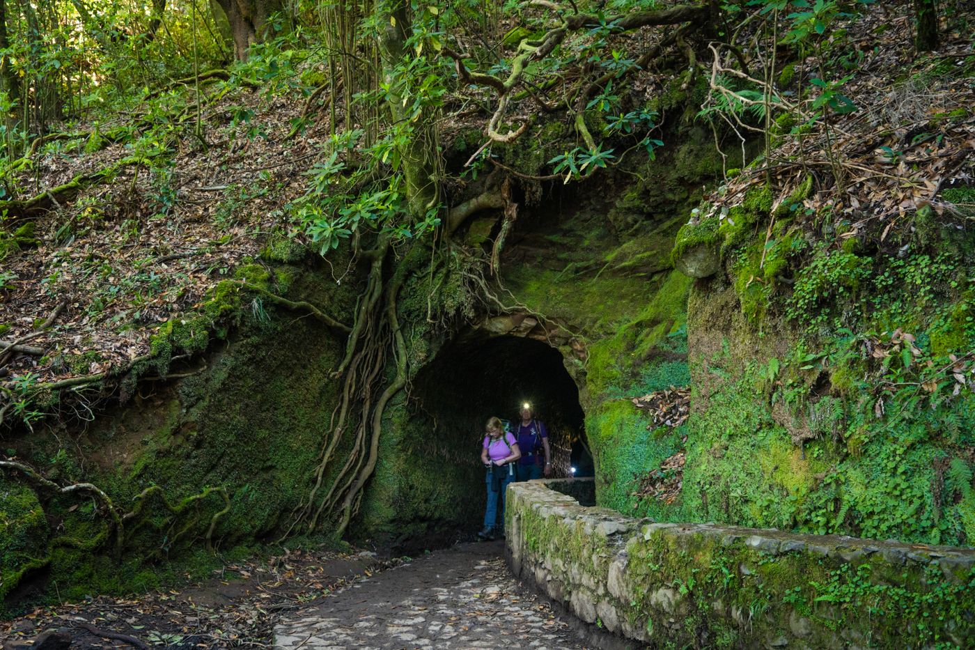
The bit nobody photographs from the airport lounge: a hand-cut tunnel on a levada trail, where a torch stops being optional.
Trails · 200+ km
The levadas, explained
Madeira has no big rivers and no flat ground to speak of, so for six hundred years it has moved water along its mountainsides by hand-cut channel. Walk beside one and you get the island's best trails almost for free.
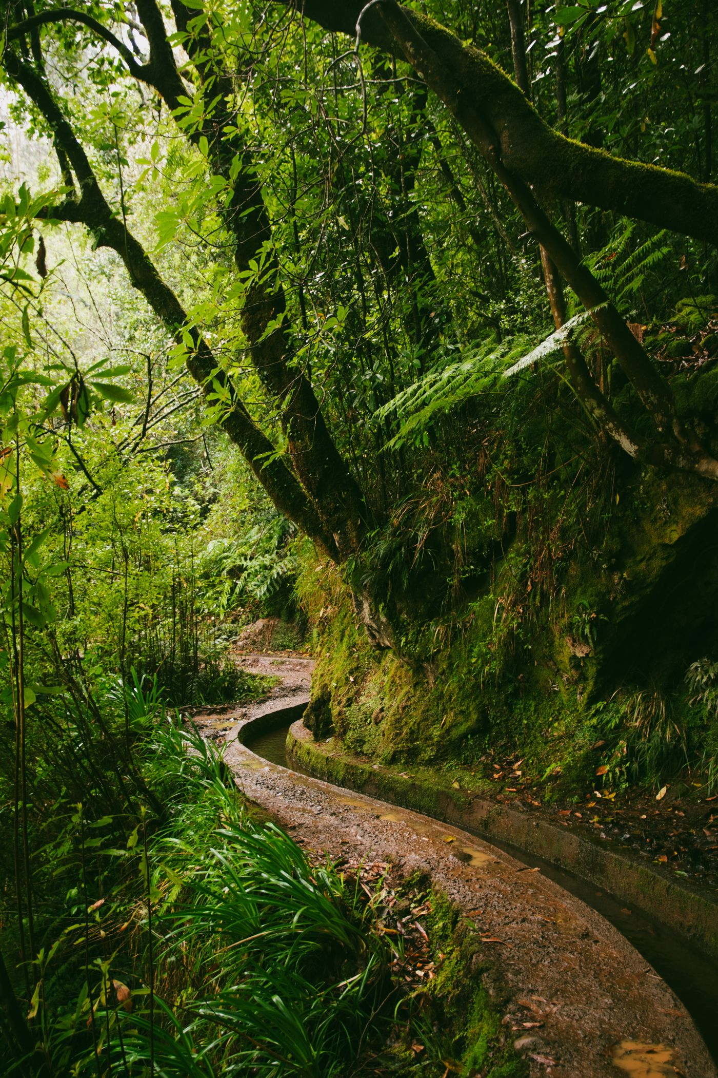
The first time the word turns up on a map it looks like a typo. Levada. It comes from the Portuguese levar, to carry, and that is exactly the job: a levada is a narrow open channel, often no wider than a roof gutter, that moves water across the island. Some run through forest, some are notched into a cliff a few hundred metres above the sea, and almost all of them have a thin path running alongside so that someone can walk the length and keep the water flowing. That maintenance path is the reason you are here.
Here is the geography in one breath. Rain and cloud pile up against the high north and west of Madeira. The south, where most people have always lived and farmed, is drier and sunnier. So from the 1400s onward the islanders cut channels to bring water from the wet side to the dry side, following the slope of the land at a barely perceptible gradient. Over the centuries that grew into a web of more than 2,170 kilometres of channel, according to the figure cited on Wikipedia's article on the levadas. Only a fraction of that has a usable walking path, but a fraction of 2,170 km is still hundreds of kilometres of trail.
Built by hand, often by people who had no choice
It is worth sitting with how these were made, because it changes how the prettier sections feel underfoot. Those earliest levadas, in the sixteenth century, were dug to water sugar cane, and the labour came largely from enslaved people brought from the Canary Islands and West Africa, alongside convicts set to the most dangerous work. Men were lowered on ropes to cut a ledge into vertical rock, hammer and chisel, with the drop below them. Around 25 kilometres of the network runs through tunnels bored straight through the mountain. Construction carried on into the 1940s, so this is not ancient history tidied up for tourists; it is engineering that people died building, still doing its original job.
Why the walking is so gentle
This is the part people don't expect. Because a channel only works if the water keeps creeping downhill, a levada has to hold an almost flat gradient the whole way. It can't climb over a ridge; it goes around it. So the path beside it inherits that near-level line, contouring around spurs and into valleys instead of going up and over. You can walk fifteen kilometres of levada and barely gain any height, which is why a long levada day leaves your legs far fresher than the distance suggests.
Flatness has a price, though, and the price is the drop. To stay level the channel often clings to a steep slope or a cliff, and the path clings with it. Some trails give you a fence or a rail. Plenty give you nothing but the channel on one side and a long way down on the other. If exposure bothers you, it is not a personal failing, it is a real feature of these walks, and you can plan around it by choosing forested, walled trails over the cliff-edge ones.
A levada will lie to you about effort. The map says fourteen kilometres and your head says hard day; the contour says otherwise and you finish wondering where the climb went.
How to read a trail before you go
The official walking routes carry a code, PR followed by a number. PR 9 is the Levada do Caldeirão Verde, PR 6 is the Levada das 25 Fontes, PR 18 is the Levada do Rei, and so on up the list. That number is just an index, not a difficulty rating, so don't read anything into a low one. Before you commit to a route, three things are worth knowing.
First, length and shape. Many levadas are linear: you walk out along the channel and the trail simply ends, often at the spring or reservoir that feeds it. That means the far end is not the start, and you will need a car or a taxi waiting there, or a walk back the way you came, or an organised walk that handles the logistics. Circular routes are the exception, not the rule. Sorting the return before you leave saves a grim hour at a trailhead with no phone signal.
Second, tunnels. Several of the best trails pass through those hand-cut tunnels, and inside it is properly dark, low in places, and dripping. A phone torch will get you through a short one. For Caldeirão Verde, where there are a handful in a row, bring a real torch and accept that you will get wet from the ceiling.
Third, the current state of the path. Trails close. After heavy rain or a rockfall a route can be shut for weeks or months while it is repaired, and a sign at the trailhead is sometimes the only warning. Check that before you drive out.
Which ones to start with
A sensible way to meet the levadas is to graduate through them rather than start at the deep end. The Levada do Rei (PR 18) is a good first proper walk: forested, mostly walled, out and back to a spring, no real exposure. The Levada do Caldeirão Verde (PR 9) ends at a tall waterfall dropping into a green bowl, and it is the one that teaches you about tunnels. The Levada das 25 Fontes, over on the west, runs through the Rabaçal valley to a pool fed by dozens of little springs, and it is busy for good reason. The Levada Nova and the levadas around Calheta give you a drier, more open, terraced version of the same idea with sea views instead of laurel forest.
None of these asks for special fitness. What they ask for is a bit of respect: the right shoes, a check that the path is open, a plan for getting back from the far end, and the sense to turn around if the cloud comes down and you can't see the edge. Do that and a centuries-old irrigation ditch becomes the best walking you will find on any island this size.