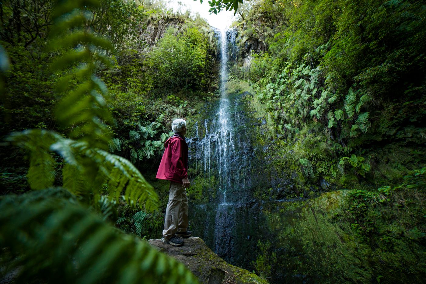
The green cauldron itself — the waterfall the levada walks out to meet.
Levada · 1000 m
Levada do Caldeirão Verde
A near-level walk through dripping laurel forest, four hand-cut tunnels and a couple of cliff edges that will get your attention, ending at a waterfall that drops into a green cauldron.
If you do one levada on Madeira and only one, most people on the island will point you to this one. It earns the reputation. The Levada do Caldeirão Verde runs along the contour of a deep valley in the green north of the island, so the walking stays almost flat the whole way, and the payoff at the far end is a tall waterfall spilling into a circular rock basin the locals call the Green Cauldron. You walk in, you take a photo, you walk back out the way you came. Simple on paper. The character is in the details.
It starts at Queimadas Forest Park, in the hills above Santana. There is a small ranger station, a few thatched-roof shelters with that distinctive Santana A-frame look, some tame chaffinches that will mug you for crumbs, and a car park that fills up fast. From there a signed path drops you onto the levada and you turn left, following the water.
At a glance
- Distance
- ~13 km return (about 6.5 km each way)
- Time
- ~4 hours return, plus stops
- Grade
- Moderate. Near-level, but exposed edges — not for bad vertigo
- Tunnels
- Several hand-cut tunnels; a torch or headlamp is essential
- Start
- Queimadas Forest Park, above Santana
What a levada actually is
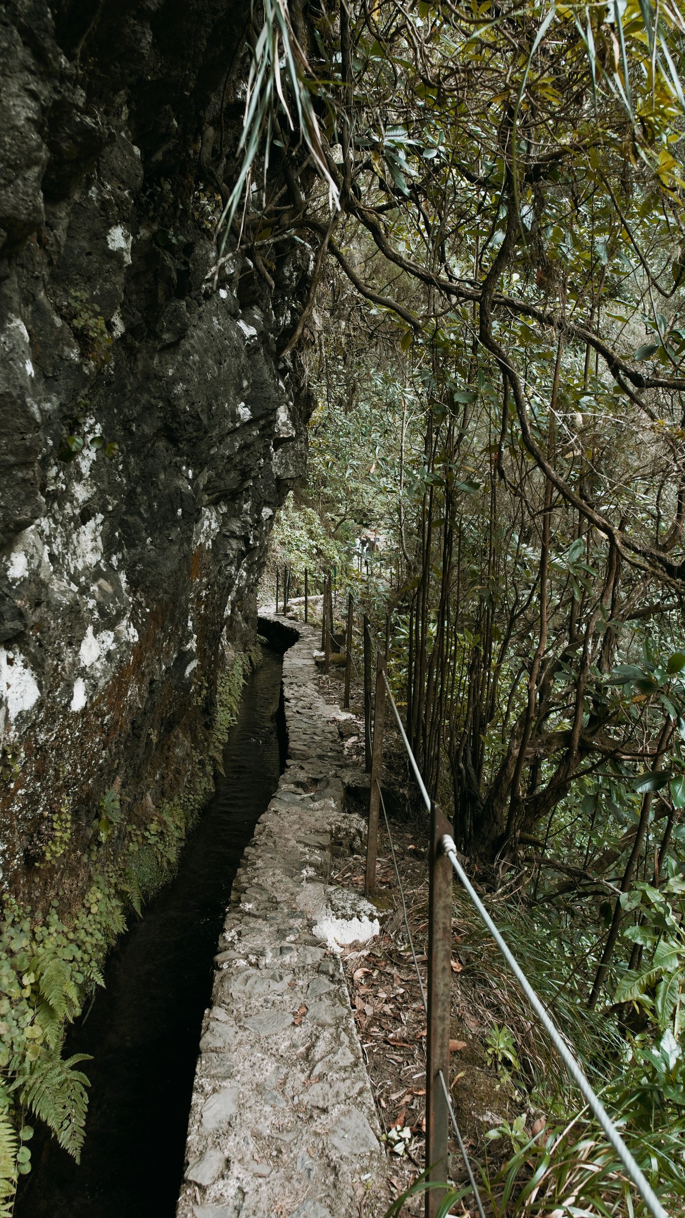
A quick aside, because it matters for understanding why this walk is so flat. Levadas are irrigation channels. Madeira has plenty of rain in the wet, mountainous north and very little where people historically wanted to grow things in the warmer south, so over a few centuries the islanders cut narrow stone aqueducts into the hillsides to move water across the island. They follow the gentlest possible gradient, because water only flows downhill if you let it down gently. A maintenance path runs alongside almost every channel. Walk the path, and you are essentially tracing a contour line carved by someone who needed the water to keep moving. That is the whole trick behind why a 13 km mountain walk barely climbs.
Beside you on this route the channel is small and quiet, maybe knee-deep, the water clear and cold. You hear it more than you watch it.
Into the laurisilva
This forest is the real thing: laurisilva, the ancient laurel woodland that once covered much of southern Europe and now survives in fragments, with Madeira holding the largest stretch left. It is dense, wet, and very green. Tree heath and laurel close overhead, ferns spill out of the rock walls, and moss coats anything that holds still long enough. After rain the whole place drips, and light comes through only in patches.
For the first stretch the path is wide and friendly and you will pass a lot of other walkers, especially mid-morning. It thins out as you go. Further in, the valley narrows and the drop on your right gets steeper.
The tunnels — bring a light, mean it
This is where the walk stops feeling like a stroll. There are several tunnels bored straight through the rock, cut by hand when the levada was built, and they are not lit. Some are short enough to see daylight at the far end. At least one is long enough and bent enough that you walk in proper darkness for a stretch, with the floor uneven underfoot and water dripping from the roof onto your neck. A phone torch will do at a push, but a headlamp is far better because you want both hands free for the wall. I have watched people turn back at the first tunnel because they came without any light at all, which is a long way to drive to give up at the interesting part.
What to take
- Light
- Headlamp ideal; phone torch as backup
- Footwear
- Grippy shoes — the path is wet and stony
- Layer
- A rain shell. The north is the wet side; it can drizzle while Funchal is sunny
- Water
- Carry your own. Don't drink from the channel
Headroom is low in places. Tall walkers end up stooping, and a few people clout their heads on the rock at least once. Take it slowly inside, let your eyes adjust, and don't rush the person in front.
The exposed edges
Between the forest and the tunnels there are sections where the levada clings to a near-vertical rock face and the ground simply falls away on the outer side. There are handrails and cables on the worst of it, and the path itself is solid, but it is genuinely exposed and the drop is real. If heights bother you, this is the part to know about before you commit. Plenty of people with mild nerves walk it fine by keeping to the inside, next to the channel, and not looking down over the edge. Bad vertigo is a different matter, and there is no shame in turning around.
It is flat, it is beautiful, and it will still get your heart rate up in two or three places. That contradiction is exactly why people love it.
The Green Cauldron
Where the levada ends, a short, rougher spur path peels off and climbs the last few minutes to the cauldron itself. The valley closes around you into a steep rock amphitheatre, and a thin waterfall comes down a tall cliff face into a dark pool at the bottom. How much water depends entirely on recent rain. After a wet spell it thunders; in a dry summer it can be more of a long silver thread. Either way the setting does the work: sheer green walls, the pool, the cold air coming off the water.
It is not a swimming spot, whatever the photos on the internet suggest. That pool is cold and the rock is slick. Have your snack, take your picture, and start back, because the return is the same distance and the tunnels feel longer when your legs are tired.
Practical notes
Go early. The Queimadas car park is small and by late morning in summer it overflows onto the access road. An early start also means quieter tunnels and a better chance of beating the cloud that builds over the north in the afternoon.
The trail closes. After heavy rain or a rockfall the authorities shut levada paths for safety, and this one is no exception. It is worth checking the official trail status before you drive out, rather than discovering a closed barrier at the start. Madeira's tourism board keeps an overview of the marked walking routes, and the forestry service publishes closures.
While you are up here, Santana is a few minutes away by car and worth a stop on the way back. The town is known for its small thatched A-frame houses, the palheiros, painted in primary colours, and a couple have been preserved for visitors to look at. After four hours in the forest, a coffee in town is a fair reward.
For wider context on the levada network and which routes are open, the official tourism site is a sensible first stop: Visit Madeira. For the history and engineering of this specific channel, the Levada do Caldeirão Verde entry on Wikipedia is a decent primer, and there is a separate one on Santana for the thatched houses. Official trail closures and conditions are managed by the island's forestry and nature institute, IFCN Madeira.
If this is your first levada and you want something gentler to warm up on, or a sense of how the channels and tunnels work before tackling this one, start with the overview of Madeira's levadas. Then, when you have a feel for it, the 25 Fontes and Rabaçal circuit makes a natural next walk.